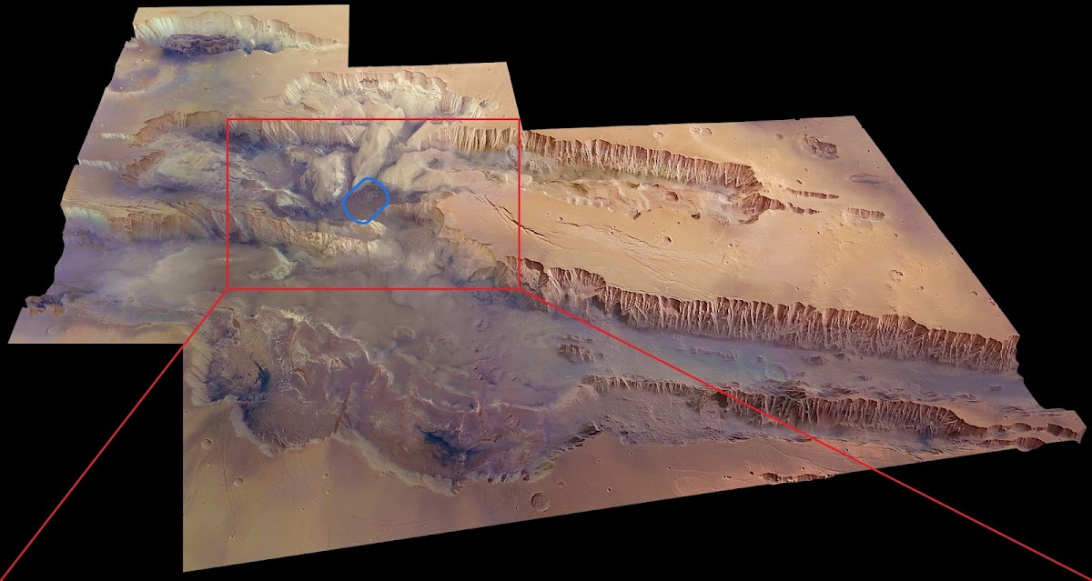
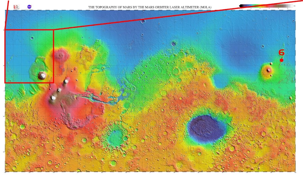
Valles Marineris (or Mariner Valleys) canyon system on Mars is one of the largest canyons of the Solar System. It is located along the equator of Mars and stretches for nearly a quarter of the planet's circumference. Valles Marineris is more than 4000 km (2500 mi) long, 200 km (120 mi) wide and up to 7 km (23,000 ft) deep.
Here is an infographic created by NASA comparing Valles Marineris to the territory of Contiguous United States (48 US states without Alaska and Hawaii) for scale:
Showing posts with label Mars Map. Show all posts
Showing posts with label Mars Map. Show all posts
Thursday, June 22, 2023
Sunday, December 19, 2021
Map of shallow subsurface water in Valles Marineris on Mars
On December 15 scientists from Space Research Institute of the Russian Academy of Sciences in Moscow, Russia revealed a discovery of an area with an unusually large amount of hydrogen in the Valles Marineris canyon system on Mars. Assuming the hydrogen is bound into water molecules, as much as 40% of the near-surface material in Candor Chaos region appears to be water. The discovery was made by neutron detector FREND on ESA&Roscosmos's ExoMars Trace Gas Orbiter orbiting Mars since October 2016. FREND is mapping the distribution of hydrogen in the uppermost meter of the planet’s surface. Hydrogen indicates the presence of water, being one of the constituents of the water molecule; it can also indicate water absorbed into the surface, or minerals that were formed in the presence of water.
While water is known to exist on Mars, most is found in the planet’s cold polar regions as ice. Typically water ice is not found exposed at the surface near the equator, as temperatures there are not cold enough for exposed water ice to be stable. Minerals seen in this part of Mars typically contain only a few percent water, much less than is evidenced by these new observations. “We found a central part of Valles Marineris to be packed full of water – far more water than we expected. This is very much like Earth’s permafrost regions, where water ice permanently persists under dry soil because of the constant low temperatures,” told one of the scientists involved in the study.
These are very inspiring discoveries for the future human colonization of Valles Marineris region we have imagined in our speculative Mars Colonization Timeline!

⇧ In the area C up to 40% of the near-surface material appears to be composed of water (by weight).
HERE is global-scale map of shallow subsurface water distribution on Mars published in 2019.
While water is known to exist on Mars, most is found in the planet’s cold polar regions as ice. Typically water ice is not found exposed at the surface near the equator, as temperatures there are not cold enough for exposed water ice to be stable. Minerals seen in this part of Mars typically contain only a few percent water, much less than is evidenced by these new observations. “We found a central part of Valles Marineris to be packed full of water – far more water than we expected. This is very much like Earth’s permafrost regions, where water ice permanently persists under dry soil because of the constant low temperatures,” told one of the scientists involved in the study.
These are very inspiring discoveries for the future human colonization of Valles Marineris region we have imagined in our speculative Mars Colonization Timeline!

⇧ In the area C up to 40% of the near-surface material appears to be composed of water (by weight).
The most water-rich area in Valles Marineris region is located in Candor Chaos:
HERE is global-scale map of shallow subsurface water distribution on Mars published in 2019.
Tuesday, March 2, 2021
SpaceX has downselected 7 potential Mars landing sites for Starship
On September 2019 it was revealed SpaceX has selected several Starship candidate landing sites on Mars. The candidate sites were located in Southern Arcadia Planitia East of Erebus Montes and one in Phlegra Montes.
Since then SpaceX has conducted several workshops with the Mars science community to evaluate and narrow the list of candidate landing sites. All the sites must fit several criteria:
Recently an abstract with the conclusions has been published (the results of the study will be presented in two weeks, at the 52nd Lunar and Planetary Science Conference), pointing out 4 prime and 3 secondary potential Starship landing sites selected for further study and located in Phlegra Montes, Erebus Montes and Southern Arcadia Planitia:
We highlighted selected ★ prime and ★ secondary sites on the map:
Since then SpaceX has conducted several workshops with the Mars science community to evaluate and narrow the list of candidate landing sites. All the sites must fit several criteria:
- close to significant deposits of water/ice, a required resource for in situ propellant production and a consumable to support habitation;
- elevation below -2 km (with respect to the MOLA geoid) that can support the delivery of large payloads, with -3 km preferred;
- latitude must be <40° for solar power and thermal management, and closer to the equator is desirable;
- multiple separate landing locations spaced within a few km of each other, to support the multiple missions needed to grow an outpost;
- slopes should be <5° over a 10 m length scale and the chance of impacting a rock greater than 0.5 m high (1 m diameter) should be <5%;
- landing site must be radar reflective to enable measurement of the distance to the surface, and it must be load bearing to support the spacecraft at touchdown.
Recently an abstract with the conclusions has been published (the results of the study will be presented in two weeks, at the 52nd Lunar and Planetary Science Conference), pointing out 4 prime and 3 secondary potential Starship landing sites selected for further study and located in Phlegra Montes, Erebus Montes and Southern Arcadia Planitia:
- PM-1 has the lowest latitude and elevation of the Phlegra Montes sites, a clear association with LDAs (local ice deposits expressed as lobate debris aprons), well developed polygons (one of the indicators of ice-related morphologies), and has the highest SWIM (Subsurface Water Ice Mapping) score for geomorphic indicators of ice;
- AP-1 (Arcadia Planitia) appears to be one of the safest sites and has a moderate combined SWIM score for ice;
- AP-9 has the thickest ice from radar returns (of the Arcadia Planitia sites) and geomorphology indicating shallow ice. It has the highest combined SWIM score for ice, but appears slightly rocky and rough;
- EM-16 has a clear association with an LDA with nearby brain terrain and the strongest radar return for shallow ice and the highest combined SWIM score of the Erebus Montes sites;
- AP-8 (Arcadia Planitia) appears to be one of the safest sites and has the highest neutron and combined SWIM scores for ice;
- EM-15 (Erebus Montes) is associated with a prominent but less extensive LDA, has well developed polygons, nearby brain terrain and appears smooth;
- PM-7 is adjacent to lineated valley fill (attributed to glacial flow) and appears to be the safest of the Phlegra sites.
We highlighted selected ★ prime and ★ secondary sites on the map:
Friday, February 19, 2021
Landing site of Perseverance Mars 2020 rover
On February 18th NASA successfully landed its Mars 2020 Perseverance rover on Mars in Jezero Crater (Western Isidis Planitia). As you may wonder where it is, we placed Perseverance's landing location on the map of Mars by National Geographic Society:
Open link in new tab to view the map in full resolution.
NASA's Jet Propulsion Laboratory has created an animated flyover of the Martian surface explaining why Jezero Crater, a 28-mile-wide ancient lake-delta system, is the best place for Perseverance to find and collect promising samples for a possible future return to Earth. The animation also reveals the route Perseverance will travel in the first years after landing:
Sunday, September 1, 2019
Candidate sites for SpaceX Starship Mars landings revealed
[on September 2 info & map updated with additional two possible landing sites]
Robert Zimmerman from BehindTheBlack.com has found several images labelled as "Candidate Landing Site for SpaceX Starship [..]" in the latest data release from University of Arizona's HiRISE camera (aboard NASA's Mars Reconnaissance Orbiter). It means that with help from NASA SpaceX is already quietly evaluating the best place where to land first Starships on Mars. Here are direct links to HiRISE image of: Site 1, Site 2, Site 3, Site 4, Site 5 (in Arcadia Planitia) & Site 6 (in Phlegra Montes).
For several years it hasn't been a secret SpaceX is considering four Martian regions for landings: Deuteronilus Mensae, Phlegra Montes, Utopia Planitia and southern Arcadia Planitia. But even in 2017 southern Arcadia Planitia looked "more promising", according to Paul Wooster, Principal Mars Development Engineer at SpaceX. So by now SpaceX may very well be down to evaluating more precise landing sites in that region.
All the candidate landing sites (except #6 in Phlegra Montes) are located on the border between Amazonis Planitia and Arcadia Planitia. According to latest data, Arcadia Planitia is one of the few regions where abundant shallow ice is present at relatively low latitudes. There is strong evidence that this location holds buried ice glaciers. So it has two critical elements looked by SpaceX for its Mars Base Alpha: solar energy and water. Those are critical not only for life support but also for refueling Starships. It's also in low altitude meaning a bit higher air pressure than in higher areas on Mars; that is beneficial for radiation protection and creates more atmospheric drag during the landing.
We made a map of all of the candidate sites:
Thursday, April 11, 2019
Map of shallow subsurface water distribution on Mars
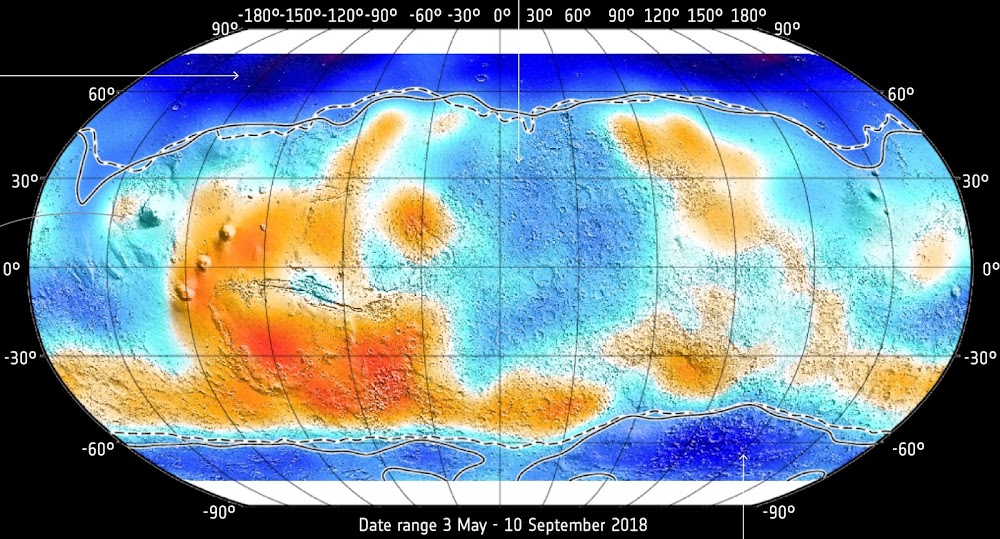
On March 10 ESA has revealed the first results from ExoMars Trace Gas Orbiter orbiting Mars since October 2016. Among the data there is the best map of shallow subsurface water distribution on Mars ever created. The map is made by orbiter's neutron detector FREND mapping the distribution of hydrogen in the uppermost metre of the planet’s surface. Hydrogen indicates the presence of water, being one of the constituents of the water molecule; it can also indicate water absorbed into the surface, or minerals that were formed in the presence of water.
- Blue areas - more water
- Orange areas - less water
Thursday, May 11, 2017
Map of possible landing sites for Red Dragon and Mars2020/ExoMars missions
Jake Robins from WeMartians Podcast has created a map of possible landing sites for SpaceX's first Red Dragon lander and NASA's Mars 2020 / ESA&Roscosmos's ExoMars rovers.
It is presumed that the most possible landing site for SpaceX's first Red Dragon lander is southern Arcadia Planitia. We will see.
- Red X = crashed/failed landings
- Green circle = successful landings
- Yellow ? mark = candidate sites for Mars2020/ExoMars
- Space "X" = candidate sites for Red Dragon
It is presumed that the most possible landing site for SpaceX's first Red Dragon lander is southern Arcadia Planitia. We will see.
Friday, March 28, 2014
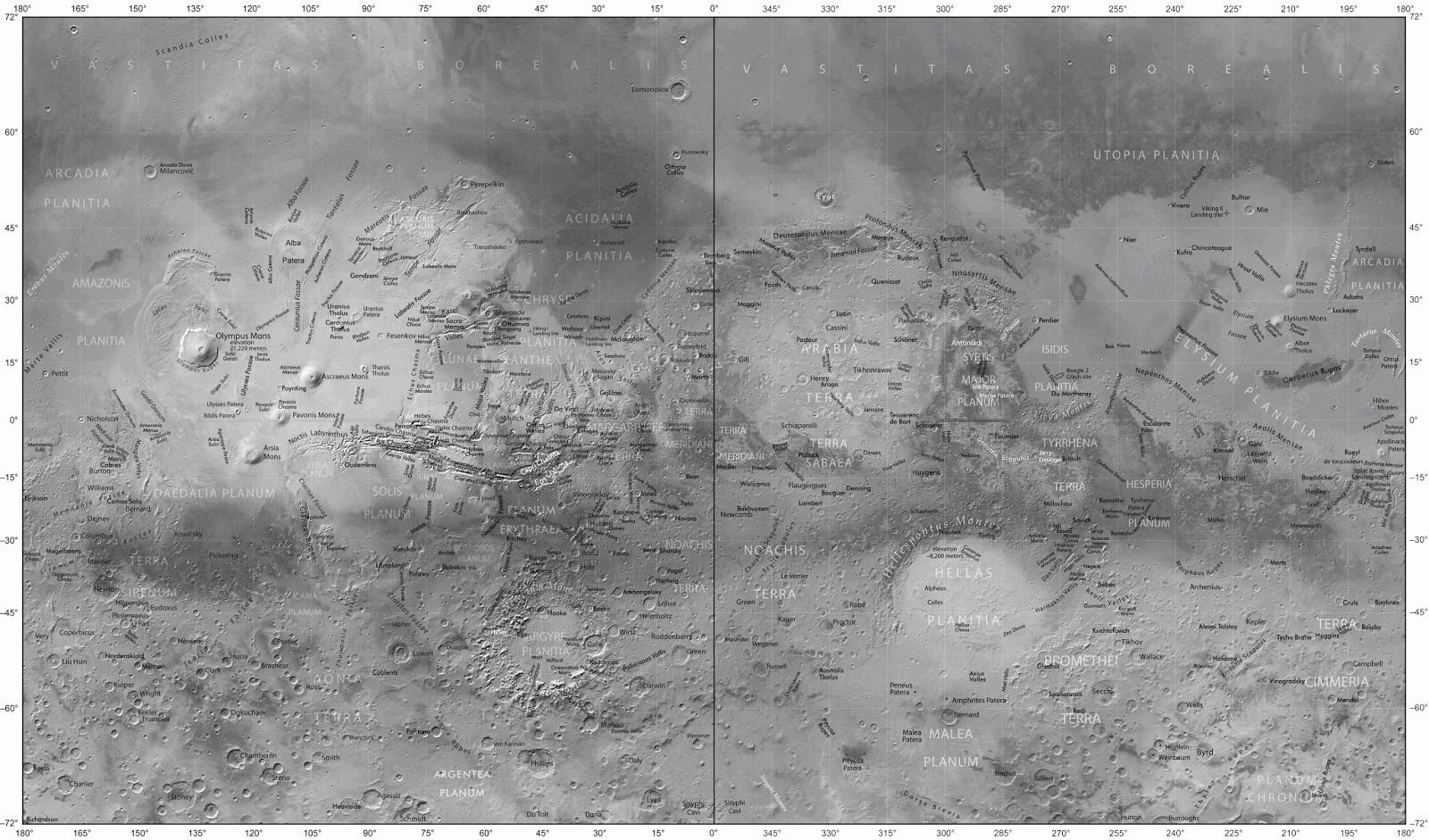
Toponymic MAP of Mars
When reading Kim Stanley Robinson's Mars trilogy I tried to find in the web a good map of Mars with enough toponyms to print out and effectively follow the story. I didn't found one. There were a few with the very basic toponymy of Mars but none to really follow the geographically rich story of Red Mars, Green Mars and Blue Mars. So I made one by myself collecting a lot of data from various maps including Google Mars. Feel free to use and share it :)
Subscribe to:
Posts (Atom)


